Region: Chubut Province · Argentina
Comodoro Rivadavia travel guide
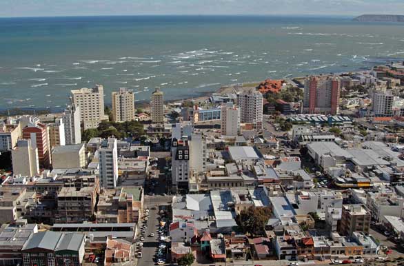

Comodoro Rivadavia is a city in Chubut Province, Argentina, home to about 202,000 people.
- Best months
- October to April
- Nearest airport
- CRD9 km · General Enrique Mosconi International Airport
- Currency
- ARSArgentine peso
- Time zone
- America/Argentina/CatamarcaUTC-3
- Plugs
- C, I · 220 V
- Emergency
- 100
- Language
- Spanish
About
About Comodoro Rivadavia
Comodoro Rivadavia, often shortened to Comodoro ( KOM-ə-DOR-oh), is a city in the Patagonian province of Chubut in southern Argentina, located on the San Jorge Gulf, an inlet of the Atlantic Ocean, at the foot of the Chenque Hill. Comodoro Rivadavia is the most important city of the San Jorge Basin, and is the largest city in Chubut as well as the largest city south of the southern 45th parallel.
Comodoro Rivadavia, often simply called Comodoro, is the center of one of the most important oil extraction regions in Argentina. Founded in 1901 as a port for the agricultural colony near Sarmiento further inland, the fate of the city changed in 1907 when petroleum was discovered. The wealth of the city has attracted numerous immigrants from all over Argentina, Chile, Bolivia and Peru. It's one of Argentina's most expensive cities to live in, mainly because of high rents. However, for visitors the prices are similar to other Patagonian cities.
Wikipedia and Wikivoyage contributors, CC BY-SA 4.0; excerpted.
Things to do
What to see and do in Comodoro Rivadavia
See
- Museo Nacional del Petróleo
- Museo Ferroportuario
- Museo Regional Patagónico Antonio Garcés
- Pinguinera Cabo Dos Bahias
Do
- El Chenque
- city beach
Wikivoyage contributors, CC BY-SA 4.0; excerpted.
Where to stay
More places to stay around Comodoro Rivadavia
Overture Maps and OpenStreetMap list 51 further hotels and other places to stay in the Comodoro Rivadavia area; 4 of them have a star rating and 1 has a room count.
By type: 44 hotels, guest houses, hostels and similar, 1 holiday rental or apartment and 6 listed only as lodging.
The area is everything within 25 km that is nearer to Comodoro Rivadavia than to any other destination in this guide. Places this guide already names are not counted again; a place listed by two sources under different names can be counted twice.
Sources: Overture Maps Foundation, places theme, release 2026-09-23.1 (CDLA Permissive 2.0); © OpenStreetMap contributors (ODbL 1.0), data of 21 September 2026.
Things to see
Things to see near Comodoro Rivadavia
Places of interest within 6 km of the centre of Comodoro Rivadavia, ranked first by how widely they are covered in Wikipedia (3 of them have articles), then the others, those linked to Wikidata first, by type of place and distance. Distances are in a straight line.
- Chenque peak, 214 m · 1.9 km
- Museo Ferroportuario museum · 1.7 km
- Museo Nacional del Petróleo museum · 3.6 km
- Museo Regional Patagónico “Profesor Antonio Garcés” museum · 0.9 km
- CEPTur Centro de Exposición y Promoción Turística museum · 1.8 km
- Cartel de Comodoro attraction · 2.2 km
- Campo de jineteada "El Palenque" attraction · 5.6 km
- Costanera beach · 2.3 km
- Mirador Cerro Chenque viewpoint · 1.6 km
- Parque Saavedra park · 2.3 km
- Cerro peak · 1.7 km
- Antena peak, 328 m · 1.7 km
- Viteau peak, 230 m · 2.8 km
- Solo peak, 68 m · 3.8 km
- Tanque peak, 321 m · 4.6 km
- Hermitte peak, 220 m · 4.9 km
OpenStreetMap maps 6 restaurants, 5 cafes and 1 bar or pub within 6 km of the centre.
Source: © OpenStreetMap contributors (ODbL 1.0), map data of 21 September 2026; links to Wikidata.
Nature
Nature near Comodoro Rivadavia
Protected areas within 50 km
- Área Natural Protegida Punta Marqués Reserva Natural Turística;Unidad de Investigación Biológica · 9.1 km
- Reserva Natural Costa Norte de Santa Cruz Área Natural Protegida · 14.8 km
- Área Natural Protegida Rocas Coloradas Área Natural Protegida · 30.3 km
Beaches within 15 km
- Costanera 2.3 km
- Balneario Rada Tilly 8.5 km
- Playa de Restinga 10.9 km
- Playa Marcela 11.3 km
- Playa Compresora 11.8 km
- Playa Belvedere 12.1 km
- Playa Granzon 14.5 km
- Playa Faro San Jorge 14.5 km
- Playa La Herradura 14.5 km
Source: © OpenStreetMap contributors (ODbL 1.0), map data of 21 September 2026; links to Wikidata.
When to go
The best time to visit Comodoro Rivadavia
The most comfortable months for a city stay in Comodoro Rivadavia are October to April. January is the warmest month, with average highs of 26 °C; June is the wettest, with about 27 mm of rain.
Comfortable means average daytime high between 18 °C and 29 °C and under 80 mm of rain in the month. Averages for 1991-2020 over the surrounding area, a grid square about 50 km across, so a coast or a nearby mountain can make the town itself warmer or cooler. Data: CRU TS v4.10, Climatic Research Unit, University of East Anglia (Open Database License).
Public holidays in Argentina, 2026
Shops and offices may close on these dates.
Getting there
Getting to Comodoro Rivadavia: airports and arrival
The nearest airport with scheduled flights is General Enrique Mosconi International Airport (CRD), about 9.3 km from the city centre in a straight line; Las Heras Airport (LHS, 135 km) is also within reach.
Getting in
The General Enrique Mosconi International Airport is located about 10 km north of the city in Próspero Palazzo neighborhood. There are daily flights to Buenos Aires and connections to cities like Córdoba, Mendoza and Neuquén. Aerolineas Argentinas and LADE, a local carrier, are the two main operators to Comodoro Rivadavia. There are seasonal flights to Chile. The bus station is located in the city center, 100 m from the Atlantic coast. There are services to Buenos Aires and most Central, North-Western and Southern Argentine provincial capitals.
Getting around
There are several bus lines serving the distinct neighborhoods and suburbs of Comodoro Rivadavia. The bus to Rada Tilly runs approximately every 30 minutes.
Wikivoyage contributors, CC BY-SA 4.0; excerpted.
CRD · General Enrique Mosconi International Airport
LHS · Las Heras Airport
Local knowledge
Eating, drinking and staying safe in Comodoro Rivadavia
Stay safe
Despite the wealth of the city, there is still a lot of poverty in Comodoro Rivadavia, and the high inequality has contributed to a relatively high crime rate. As a visitor, you should be wary like in the large Argentine cities and avoid walking around in poorer suburbs, particularly at night.
Wikivoyage contributors, CC BY-SA 4.0; excerpted.
Questions
Comodoro Rivadavia: questions travellers ask
When is the best time to visit Comodoro Rivadavia?
The most comfortable months for a city stay in Comodoro Rivadavia are October to April. January is the warmest month, with average highs of 26 °C; June is the wettest, with about 27 mm of rain.
Which airport is closest to Comodoro Rivadavia?
The nearest airport with scheduled flights is General Enrique Mosconi International Airport (CRD), about 9.3 km from the city centre in a straight line; Las Heras Airport (LHS, 135 km) is also within reach.
What currency is used in Comodoro Rivadavia?
The Argentine peso (ARS), per Unicode CLDR.
Nearby
Destinations near Comodoro Rivadavia
Sources: city facts from Wikidata and Wikipedia; airports from OurAirports; climate from CRU TS v4.10 (University of East Anglia Climatic Research Unit), 1991-2020 monthly means, 0.5° grid; public holidays from python-holidays (MIT); currency and official languages from Unicode CLDR (Unicode License v3); time zone from the coordinates (timezone-boundary-builder, ODbL) with offsets from the IANA Time Zone Database; places to stay and guest scores from each operator's own public pages; amenities from the operators' own listing data. How this guide is made.