Region: Santa Catarina · Brazil
Where to stay in Itajaí
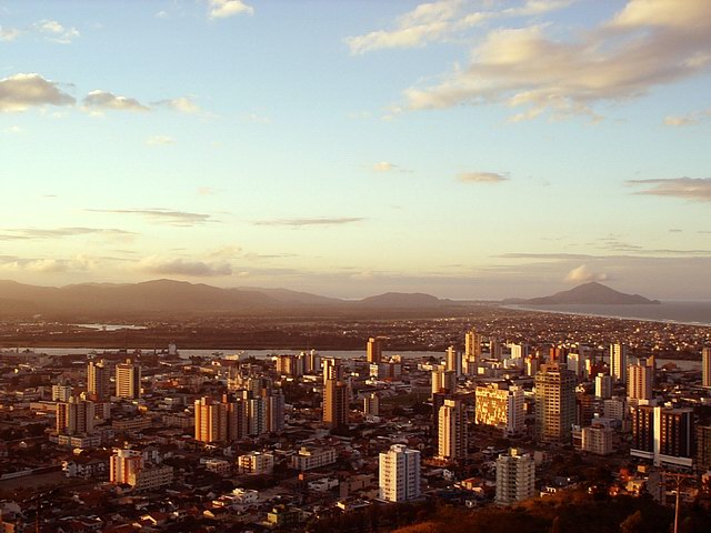

Itajaí is a city in Santa Catarina, Brazil, home to about 264,000 people.
- Nearest airport
- NVT3 km · Ministro Victor Konder International Airport
- Currency
- BRLBrazilian real
- Time zone
- America/Sao PauloUTC-3
- Plugs
- C, N · 220 V
- Emergency
- 190
- Language
- Portuguese
About
About Itajaí
Itajaí is a municipality in the state of Santa Catarina, Brazil. It is located on the northern central coast of Santa Catarina and is part of the Vale do Itajaí Mesoregion, on the right bank of the Itajaí-Açu river mouth.
Wikipedia contributors, CC BY-SA 4.0; excerpted.
Things to do
What to see and do in Itajaí
See
- Bat's Beach
- Brava Beach
- Igreja Matriz
- Igreja Imaculada Conceição
Wikivoyage contributors, CC BY-SA 4.0; excerpted.
Where to stay
Hotels in Itajaí
6 hotels within 25 km of the centre, as recorded in Wikidata. Each name links to its encyclopedia article where there is one.
| Hotel | Opened | From centre |
|---|---|---|
| Hotel Estação 101 - Itajaí | 5.9 km | |
| Hotel Itajaí Tur | 0.8 km | |
| Hotel Valerim Itajaí / Navegantes | 0.7 km | |
| Mercure Itajaí Navegantes | 0.6 km | |
| Novotel Itajai | 0.7 km | |
| Sandri Palace Hotel | 1.7 km |
Where to stay
More places to stay around Itajaí
Overture Maps and OpenStreetMap list 60 further hotels and other places to stay in the Itajaí area; none of them has a star rating and 1 has a room count.
By type: 42 hotels, guest houses, hostels and similar, 5 holiday rentals and apartments and 13 listed only as lodging.
The area is everything within 25 km that is nearer to Itajaí than to any other destination in this guide. Places this guide already names are not counted again; a place listed by two sources under different names can be counted twice.
Sources: Overture Maps Foundation, places theme, release 2026-09-23.1 (CDLA Permissive 2.0); © OpenStreetMap contributors (ODbL 1.0), data of 21 September 2026.
Things to see
Things to see near Itajaí
Places of interest within 6 km of the centre of Itajaí, none of them with an article in Wikipedia, ranked with those linked to Wikidata first, then by type of place and distance. Distances are in a straight line.
- Museu Histórico de Itajaí museum · 0.1 km
- Igreja Nossa Senhora dos Navegantes attraction · 1.1 km
- Bico do Papagaio attraction · 2.6 km
- Portico de Itajaí attraction · 4.3 km
- Praia do Pontal beach · 1.9 km
- Praia dos Molhes beach · 2.3 km
- Praia da Atalaia beach · 2.3 km
- Praia Central beach · 2.4 km
- Praia do Jeremias beach · 2.7 km
- Praia de Cabeçudas beach · 3.6 km
- Praia da Solidão beach · 4.4 km
- Praia do Morcego beach · 4.4 km
- Praia Brava Norte beach · 4.7 km
- Meia Praia beach · 5.3 km
- Praia Brava Sul beach · 5.6 km
- Mirante João Sandri viewpoint · 1.2 km
OpenStreetMap maps 55 restaurants, 4 cafes and 24 bars and pubs within 6 km of the centre.
Source: © OpenStreetMap contributors (ODbL 1.0), map data of 21 September 2026.
Nature
Nature near Itajaí
Protected areas within 50 km
- Parque Natural Municipal Ilha das Capivaras/Sibara parque natural municipal · 3.3 km
- Parque Natural Municipal Raimundo Gonçález Malta parque natural municipal · 11.3 km
- Bosque do Garapuvu Área de Relevante Interesse Ecológico · 34.3 km
- Arvoredo Marine Biological Reserve reserva biológica · 36.5 km
- Parque Nacional da Serra do Itajaí national park · 37.9 km
Beaches within 15 km
- Praia do Pontal 1.9 km
- Praia dos Molhes 2.3 km
- Praia da Atalaia 2.3 km
- Praia Central 2.4 km
- Praia do Jeremias 2.7 km
- Praia de Cabeçudas 3.6 km
- Praia da Solidão 4.4 km
- Praia do Morcego 4.4 km
- Praia Brava Norte 4.7 km
- Meia Praia 5.3 km
- Praia Brava Sul 5.6 km
- Praia dos Amores 6.6 km
- Praia das Conchas 7.1 km
- Praia do Buraco 7.4 km
- Praia do Gravatá 8.0 km
Source: © OpenStreetMap contributors (ODbL 1.0), map data of 21 September 2026; links to Wikidata.
When to go
The best time to visit Itajaí
Itajaí has no month that is both mild and dry by the measure used here. January is the warmest month, with average highs of 29 °C; February is the wettest, with about 249 mm of rain.
Comfortable means average daytime high between 18 °C and 29 °C and under 80 mm of rain in the month. Averages for 1991-2020 over the surrounding area, a grid square about 50 km across, so a coast or a nearby mountain can make the town itself warmer or cooler. Data: CRU TS v4.10, Climatic Research Unit, University of East Anglia (Open Database License).
Public holidays in Brazil, 2026
Shops and offices may close on these dates.
Getting there
Getting to Itajaí: airports and arrival
The nearest airport with scheduled flights is Ministro Victor Konder International Airport (NVT), about 3.3 km from the city centre in a straight line; Lauro Carneiro de Loyola Airport (JOI, 77 km) and Hercílio Luz International Airport (FLN, 86 km) are also within reach.
NVT · Ministro Victor Konder International Airport
JOI · Lauro Carneiro de Loyola Airport
FLN · Hercílio Luz International Airport
Getting around
Getting there and around Itajaí by rail and ferry
Ferries
One ferry route in service calls at Itajaí. Distances are from the centre to the route's nearest pier here.
- Itajaí - Navegantes 0.7 km
Source: © OpenStreetMap contributors (ODbL 1.0), map data of 21 September 2026.
Questions
Itajaí: questions travellers ask
When is the best time to visit Itajaí?
Itajaí has no month that is both mild and dry by the measure used here. January is the warmest month, with average highs of 29 °C; February is the wettest, with about 249 mm of rain.
Which airport is closest to Itajaí?
The nearest airport with scheduled flights is Ministro Victor Konder International Airport (NVT), about 3.3 km from the city centre in a straight line; Lauro Carneiro de Loyola Airport (JOI, 77 km) and Hercílio Luz International Airport (FLN, 86 km) are also within reach.
What currency is used in Itajaí?
The Brazilian real (BRL), per Unicode CLDR.
Nearby
Destinations near Itajaí
Sources: city facts from Wikidata and Wikipedia; airports from OurAirports; climate from CRU TS v4.10 (University of East Anglia Climatic Research Unit), 1991-2020 monthly means, 0.5° grid; public holidays from python-holidays (MIT); currency and official languages from Unicode CLDR (Unicode License v3); time zone from the coordinates (timezone-boundary-builder, ODbL) with offsets from the IANA Time Zone Database; places to stay and guest scores from each operator's own public pages; amenities from the operators' own listing data. How this guide is made.