Region: California · United States
Murrieta travel guide
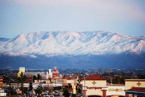

Murrieta is a city in California, United States, home to about 111,000 people.
- Best months
- February to June, October and November
- Nearest airport
- CLD50 km · McClellan-Palomar Airport
- Currency
- USDUS dollar
- Time zone
- America/Los AngelesUTC-8, UTC-7 with daylight saving time
- Plugs
- A, B · 120 V
- Emergency
- 911
- Language
- English
Where to stay
More places to stay around Murrieta
Overture Maps and OpenStreetMap list 20 further hotels and other places to stay in the Murrieta area; none of them has a star rating and none has a room count.
By type: 10 hotels, guest houses, hostels and similar, 4 holiday rentals and apartments and 6 listed only as lodging.
The area is everything within 25 km that is nearer to Murrieta than to any other destination in this guide. Places this guide already names are not counted again; a place listed by two sources under different names can be counted twice.
Sources: Overture Maps Foundation, places theme, release 2026-09-23.1 (CDLA Permissive 2.0); © OpenStreetMap contributors (ODbL 1.0), data of 21 September 2026.
Things to see
Things to see near Murrieta
Places of interest within 6 km of the centre of Murrieta, ranked first by how widely they are covered in Wikipedia (one of them has an article), then the others, those linked to Wikidata first, by type of place and distance. Distances are in a straight line.
- Chaney Hill peak, 374 m · 3.8 km
- Mulligan Family Fun Center theme park · 1.1 km
- Miniature Golf attraction · 1.0 km
- Batting Cage attraction · 1.0 km
- Frog Hopper attraction · 1.0 km
- Western Train attraction · 1.0 km
- Big Splash Pumping Station attraction · 1.1 km
- Tea Cups attraction · 1.1 km
- Mulligan Racing Rookie Track attraction · 1.1 km
- Arcade attraction · 1.1 km
- Rock Wall attraction · 1.1 km
- Redemption Games attraction · 1.1 km
- Glow Room attraction · 1.1 km
- Mulligan Speedway attraction · 1.1 km
- Lazer Xtreme attraction · 1.1 km
- Murrieta Historic Downtown attraction · 2.0 km
- Hurricane Simulator attraction · 2.2 km
- Cageball attraction · 2.2 km
- Kids Trampoline Arena attraction · 2.2 km
- Dodgeball attraction · 2.2 km
OpenStreetMap maps 70 restaurants, 29 cafes and 4 bars and pubs within 6 km of the centre.
Source: © OpenStreetMap contributors (ODbL 1.0), map data of 21 September 2026; links to Wikidata.
Nature
Nature near Murrieta
Protected areas within 50 km
- Santa Rosa Plateau Ecological Reserve 3.8 km
- Santa Margarita Ecological Reserve 11.8 km
- San Mateo Canyon Wilderness Wilderness Area · 13.3 km
- Agua Tibia Wilderness Wilderness Area · 19.8 km
- Ronald W. Caspers Wilderness Park Wilderness Park · 28.6 km
- Cahuilla Mountain Wilderness Wilderness Area · 35.2 km
- Beauty Mountain Wilderness Wilderness Area · 35.2 km
- Thomas F. Riley Wilderness Park Wilderness Park · 35.8 km
- South Fork San Jacinto Wilderness Wilderness Area · 36.1 km
- O'Neill Regional Park 36.8 km
- Beauty Mountain Wilderness Study Area Wilderness Study Area · 39.0 km
- Modjeska Canyon and Tucker Wildlife Sanctuary 40.6 km
- Whiting Ranch Wilderness Park Wilderness Park · 41.6 km
- San Timoteo Canyon State Park · 44.3 km
- Aliso and Wood Canyons Wilderness Park 46.9 km
- Carlsbad State Beach 48.1 km
- Dana Point State Marine Conservation Area State Marine Conservation Area · 48.2 km
Source: © OpenStreetMap contributors (ODbL 1.0), map data of 21 September 2026; links to Wikidata.
When to go
The best time to visit Murrieta
The most comfortable months for a city stay in Murrieta are February to June, October and November. August is the warmest month, with average highs of 33 °C; January is the wettest, with about 83 mm of rain.
Comfortable means average daytime high between 18 °C and 29 °C and under 80 mm of rain in the month. Averages for 1991-2020 over the surrounding area, a grid square about 50 km across, so a coast or a nearby mountain can make the town itself warmer or cooler. Data: CRU TS v4.10, Climatic Research Unit, University of East Anglia (Open Database License).
Public holidays in United States, 2026
Shops and offices may close on these dates.
Getting there
Getting to Murrieta: airports and arrival
The nearest airport with scheduled flights is McClellan-Palomar Airport (CLD), about 50 km from the city centre in a straight line; San Bernardino International Airport (SBD, 59 km) and John Wayne Orange County International Airport (SNA, 63 km) are also within reach.
CLD · McClellan-Palomar Airport
SBD · San Bernardino International Airport
SNA · John Wayne Orange County International Airport
Questions
Murrieta: questions travellers ask
When is the best time to visit Murrieta?
The most comfortable months for a city stay in Murrieta are February to June, October and November. August is the warmest month, with average highs of 33 °C; January is the wettest, with about 83 mm of rain.
Which airport is closest to Murrieta?
The nearest airport with scheduled flights is McClellan-Palomar Airport (CLD), about 50 km from the city centre in a straight line; San Bernardino International Airport (SBD, 59 km) and John Wayne Orange County International Airport (SNA, 63 km) are also within reach.
What currency is used in Murrieta?
The US dollar (USD), per Unicode CLDR.
Nearby
Destinations near Murrieta
Sources: city facts from Wikidata and Wikipedia; airports from OurAirports; climate from CRU TS v4.10 (University of East Anglia Climatic Research Unit), 1991-2020 monthly means, 0.5° grid; public holidays from python-holidays (MIT); currency and official languages from Unicode CLDR (Unicode License v3); time zone from the coordinates (timezone-boundary-builder, ODbL) with offsets from the IANA Time Zone Database; places to stay and guest scores from each operator's own public pages; amenities from the operators' own listing data. How this guide is made.