Region: New Jersey · United States
Paterson travel guide
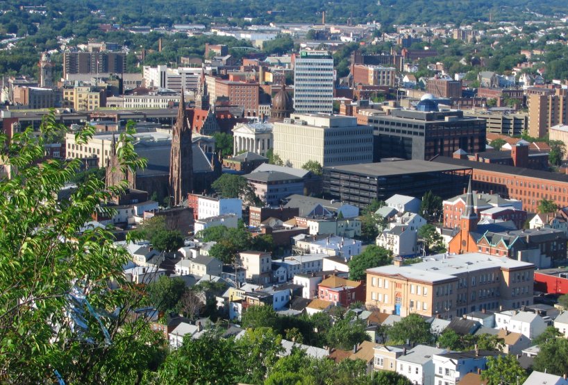

Paterson is a city in New Jersey, United States, home to about 160,000 people.
- Nearest airport
- TEB12 km · Teterboro Airport
- Currency
- USDUS dollar
- Time zone
- America/New YorkUTC-5, UTC-4 with daylight saving time
- Plugs
- A, B · 120 V
- Emergency
- 911
- Language
- English
About
About Paterson
Paterson was the nation's first planned industrial city. It was established in 1791. The Paterson falls were a key element in the success of Paterson as the industrial leader of the nation during this time. The 77-foot falls' power was harnessed and provided power for the many industries in Paterson. Paterson was a rich city and enjoyed success throughout the late 1700s, 1800s and early 1900s (up until the 1950s). Paterson was nicknamed the silk city for its dominant role in the production in silk during the mid 1800s.
Wikivoyage contributors, CC BY-SA 4.0; excerpted.
Things to do
What to see and do in Paterson
See
- The Great Falls
- Lambert Castle
- American Labor Museum
Do
There are also many night clubs in Paterson catering to the hip hop and Latino communities. Though some of these clubs run illegally. It is best to stay with legitimate clubs in Downtown Paterson.
Wikivoyage contributors, CC BY-SA 4.0; excerpted.
Where to stay
Which part of Paterson to stay in
There are not that many hotels in Paterson. It is better to visit Paterson by day, or sleep over in a motel near Paterson.
Wikivoyage contributors, CC BY-SA 4.0; excerpted.
Where to stay
More places to stay around Paterson
Overture Maps and OpenStreetMap list 47 further hotels and other places to stay in the Paterson area; none of them has a star rating and none has a room count.
By type: 26 hotels, guest houses, hostels and similar, no holiday rentals and 21 listed only as lodging.
The area is everything within 25 km that is nearer to Paterson than to any other destination in this guide. Places this guide already names are not counted again; a place listed by two sources under different names can be counted twice.
Sources: Overture Maps Foundation, places theme, release 2026-09-23.1 (CDLA Permissive 2.0); © OpenStreetMap contributors (ODbL 1.0), data of 21 September 2026.
Things to see
Things to see near Paterson
Places of interest within 6 km of the centre of Paterson, ranked first by how widely they are covered in Wikipedia (10 of them have articles), then the others, those linked to Wikidata first, by type of place and distance. Distances are in a straight line.
- Paterson Museum museum · 0.7 km
- Pietro and Maria Botto House museum · 2.4 km
- Yogi Berra Museum & Learning Center museum · 5.7 km
- West Side Park park · 1.5 km
- Eastside Park park · 3.0 km
- Lance Corporal Ralph Valt Memorial Park park · 4.7 km
- Shai Shacknai Memorial Park park · 5.2 km
- Weasel Brook Park park · 5.6 km
- MacDonald Drive Park park · 5.7 km
- Mount Cecchino peak, 230 m · 5.9 km
- Cadmus House Historical Museum museum · 5.0 km
- Hamilton House Museum museum · 5.7 km
- William Paterson University Galleries gallery · 3.6 km
- Ben Shahn Center for the Visual Arts gallery · 4.0 km
- Sunrise Art Studio gallery · 5.2 km
- Goffle Brook Park park · 4.1 km
- Mountain Top View viewpoint · 4.2 km
- Main Memorial Park park · 4.3 km
- Reservoir View viewpoint · 4.7 km
- Anzaldi Park park · 4.9 km
OpenStreetMap maps 177 restaurants, 22 cafes and 17 bars and pubs within 6 km of the centre.
Source: © OpenStreetMap contributors (ODbL 1.0), map data of 21 September 2026; links to Wikidata.
Nature
Nature near Paterson
Protected areas within 50 km
The list shows 20 of the 78 protected areas OpenStreetMap maps within 50 km: the nearest ones, by distance to their nearest edge.
- Franklin Swamp 8.9 km
- Great Piece Meadows Preserve Preserve · 8.9 km
- Stevens Avenue Woods 9.6 km
- Campgaw Mountain Reservation Reservation · 13.4 km
- Celery Farm Natural Area Natural Area · 13.5 km
- Ramapo Mountain State Forest State Forest · 13.8 km
- H & T Property 14.8 km
- Deer Trail North Property 14.9 km
- Suraci Pond Property 15.1 km
- O'Kane Park 15.2 km
- Ramapo Valley County Reservation Reservation · 15.3 km
- Thomas Edison National Historical Park National Historical Park · 15.5 km
- Royale Tract 15.6 km
- Shultz Property 16.2 km
- Mayor Jonathan Dunleavy Memorial Park 16.7 km
- Elbert Street Property 16.9 km
- Rockaway River Wildlife Management Area Wildlife Management Area · 18.2 km
- Norvin Green State Forest State Forest · 18.4 km
- Ringwood State Park State Park · 18.8 km
- Silas Condict County Park 19.4 km
Beaches within 15 km
- East Beach 7.1 km
- West Beach 7.4 km
- Lionshead Lake Beach 9.8 km
- Rutherford Waterfront Park 10.6 km
- Pines Lake West Beach 11.8 km
- Sunny Ridge Beach 12.2 km
Ski areas within 40 km
- Big Snow American Dream 4 lifts · 14.6 km
- Campgaw Mountain Ski Area 7 lifts · 16.0 km
- Mount Peter 6 lifts · 38.1 km
- National Winter Activity Center 3 lifts · 39.4 km
Source: © OpenStreetMap contributors (ODbL 1.0), map data of 21 September 2026; links to Wikidata.
When to go
The best time to visit Paterson
Paterson has no month that is both mild and dry by the measure used here. July is the warmest month, with average highs of 30 °C; July is the wettest, with about 124 mm of rain.
Comfortable means average daytime high between 18 °C and 29 °C and under 80 mm of rain in the month. Averages for 1991-2020 over the surrounding area, a grid square about 50 km across, so a coast or a nearby mountain can make the town itself warmer or cooler. Data: CRU TS v4.10, Climatic Research Unit, University of East Anglia (Open Database License).
Public holidays in United States, 2026
Shops and offices may close on these dates.
Getting there
Getting to Paterson: airports and arrival
The nearest airport with scheduled flights is Teterboro Airport (TEB), about 12 km from the city centre in a straight line; Newark Liberty International Airport (EWR, 25 km) and LaGuardia Airport (LGA, 30 km) are also within reach.
Getting in
Paterson is easily accessible via Route 80 and Route 4 in New Jersey. The Main Line run by NJ Transit has a stop in Paterson. There are jitneys (a type of van) that run along Route 4 from the Port Authority George Washington Bridge terminal in Upper Manhattan, and there are also New Jersey Transit buses from the main Port Authority terminal near Times Square.
Getting around
Paterson is a small city in area: it is only 8 square miles, but it has more than 150,000 residents. There are many bus lines that come frequently enough that you can travel from the city without a car. Paterson is a major transit hub for Passaic County, and North Jersey. New Jersey Transit provide bus routes into and out of the city. Route 161, 190, and 171 provide service from Paterson to New York City. Route 72, provides service from Paterson to Newark's Penn Station. Also,route 74 702,703,704,707,712,722, (742 Sat Only), 744, 746, and 748 provide service throughout the city.
Wikivoyage contributors, CC BY-SA 4.0; excerpted.
TEB · Teterboro Airport
EWR · Newark Liberty International Airport
LGA · LaGuardia Airport
Getting around
Getting there and around Paterson by rail and ferry
Rail from the airports
Rail, metro and tram lines that call at a station at the airport, as mapped in OpenStreetMap.
- EWR · Newark Liberty International AirportRail (Amtrak): Keystone Service, Northeast RegionalRail (NJ Transit): NEC, North Jersey Coast
Source: © OpenStreetMap contributors (ODbL 1.0), map data of 21 September 2026.
Local knowledge
Eating, drinking and staying safe in Paterson
Eat
There are many Dominican, Peruvian, Italian, Puerto Rican, Arab, & African restaurants in Paterson.
Stay safe
Though Paterson has a reputation of being a crime-ridden city, it is not all doom and gloom as many suburbanites would suggest. In fact, Paterson's crime rate is comparable to that of mid-sized Midwestern cities, such as Grand Rapids, Michigan. That said, one should exercise ordinary caution when visiting the city. Most of the crime in Paterson is in certain sections: Wrigley Park (4th Ward), Northside, and parts of Riverside, Totowa Section and Sandy Hill. It is best to avoid drug areas such as the 4th Ward or Northside. Most crime in Paterson is said to be drug related.
Wikivoyage contributors, CC BY-SA 4.0; excerpted.
Questions
Paterson: questions travellers ask
When is the best time to visit Paterson?
Paterson has no month that is both mild and dry by the measure used here. July is the warmest month, with average highs of 30 °C; July is the wettest, with about 124 mm of rain.
Which airport is closest to Paterson?
The nearest airport with scheduled flights is Teterboro Airport (TEB), about 12 km from the city centre in a straight line; Newark Liberty International Airport (EWR, 25 km) and LaGuardia Airport (LGA, 30 km) are also within reach.
What currency is used in Paterson?
The US dollar (USD), per Unicode CLDR.
Nearby
Destinations near Paterson
Sources: city facts from Wikidata and Wikipedia; airports from OurAirports; climate from CRU TS v4.10 (University of East Anglia Climatic Research Unit), 1991-2020 monthly means, 0.5° grid; public holidays from python-holidays (MIT); currency and official languages from Unicode CLDR (Unicode License v3); time zone from the coordinates (timezone-boundary-builder, ODbL) with offsets from the IANA Time Zone Database; places to stay and guest scores from each operator's own public pages; amenities from the operators' own listing data. How this guide is made.