Region: Wales · United Kingdom
Where to stay in Pencoed
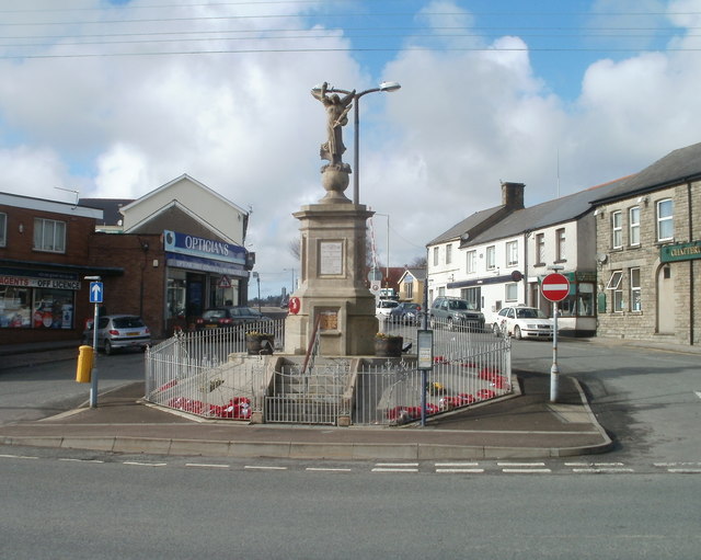

Pencoed is a city in Wales, United Kingdom, home to about 9,000 people. This guide covers 1 hotel in Pencoed. Every one carries a published guest score, and the list below is ordered by it.
- Places to stay in this guide
- 1
- Nearest airport
- CWL18 km · Cardiff International Airport
- Currency
- GBPBritish pound
- Time zone
- Europe/LondonUTC+0, UTC+1 with daylight saving time
- Plugs
- G · 230 V
- Emergency
- 112
- Language
- English
About
About Pencoed
Pencoed (also Pen-coed; ) is a town and community in the county borough of Bridgend, Wales. It straddles the M4 motorway north east of Bridgend and is situated on the Ewenny River.
Wikipedia contributors, CC BY-SA 4.0; excerpted.
Where to stay
The best-rated places to stay in Pencoed
Ordered by guest score as each operator publishes it, weighted by the number of reviews so a handful of perfect scores does not outrank thousands of very good ones. Scores are shown on their own scale.
| # | Place to stay | Rooms | Guest score |
|---|---|---|---|
| 1 | Travelodge Bridgend Pencoed hotel | ≈ 59 est. | 4.0/5 737 reviews |
Schematic: the city centre in orange, each place to stay as a dot, distance rings in kilometres.
Where to stay
Where the places to stay in Pencoed are
18 places to stay in this guide with known coordinates, grouped by straight-line distance from the city centre (the point Wikidata gives for Pencoed), nearest first. Distance on foot or by road is longer.
11 places
- Star Inn · 3.4 km
- Golden Mile · 5.1 km
- Wyndham Hotel,Dunraven Place · 5.5 km
- Hazelwood House · 5.7 km
- Court Colman Manor · 6.4 km
- Ewenny Farm Guest House · 6.9 km
- New Inn Lodge · 7.4 km
- Bear Inn · 7.7 km
- The Laleston Inn · 8.3 km
- Tŷ Mawr Aka The Great House · 8.4 km
- Portobello House · 9.9 km
5 places
- Marine Hotel, Southerndown · 11.5 km
- Ballas Farm Country Guest House · 11.9 km
- The Old House Inn PH · 12.3 km
- Olivia House · 14.9 km
- Seabank Hotel · 15.0 km
Where to stay
More hotels in Pencoed
17 hotels within 25 km of the centre, as recorded in Wikidata. Each name links to its encyclopedia article where there is one.
| Hotel | Opened | From centre |
|---|---|---|
| Bear Inn | 7.7 km | |
| Seabank Hotel | 1860 | 15.0 km |
| Court Colman Manor | 6.4 km | |
| Portobello House | 9.9 km | |
| The Laleston Inn | 8.3 km | |
| Tŷ Mawr Aka The Great House | 8.4 km | |
| Wyndham Hotel,Dunraven Place | 5.5 km | |
| Ballas Farm Country Guest House | 11.9 km | |
| Ewenny Farm Guest House | 6.9 km | |
| Golden Mile | 5.1 km | |
| Hazelwood House | 5.7 km | |
| Marine Hotel, Southerndown | 11.5 km | |
| New Inn Lodge | 7.4 km | |
| Olivia House | 14.9 km | |
| Star Inn | 3.4 km | |
| The Coed-Y-Mwstwr Hotel | 1.6 km | |
| The Old House Inn PH | 12.3 km |
Where to stay
More places to stay around Pencoed
Overture Maps and OpenStreetMap list 94 further hotels and other places to stay in the Pencoed area; none of them has a star rating and 1 has a room count.
By type: 73 hotels, guest houses, hostels and similar, 18 holiday rentals and apartments and 3 listed only as lodging.
The area is everything within 25 km that is nearer to Pencoed than to any other destination in this guide. Places this guide already names are not counted again; a place listed by two sources under different names can be counted twice.
Sources: Overture Maps Foundation, places theme, release 2026-09-23.1 (CDLA Permissive 2.0); © OpenStreetMap contributors (ODbL 1.0), data of 21 September 2026.
Things to see
Things to see near Pencoed
Places of interest within 3 km of the centre of Pencoed, none of them with an article in Wikipedia, ranked with those linked to Wikidata first, then by type of place and distance. Distances are in a straight line.
- Pencoed War Memorial memorial · 0.3 km
OpenStreetMap maps 2 restaurants, 1 cafe and 6 bars and pubs within 3 km of the centre.
Source: © OpenStreetMap contributors (ODbL 1.0), map data of 21 September 2026; links to Wikidata.
Nature
Nature near Pencoed
Protected areas within 50 km
The list shows 20 of the 40 protected areas OpenStreetMap maps within 50 km: all 2 national parks and the nearest other areas, by distance to their nearest edge.
- Tremains Wood Local Nature Reserve 3.6 km
- Merthyr Mawr Warren National Nature Reserve National Nature Reserve · 9.4 km
- Kenfig National Nature Reserve National Nature Reserve · 14.9 km
- Nelson Bog Site of Special Scientific Interest · 21.3 km
- Caeau Nant y Groes SSSI Site of Special Scientific Interest · 21.6 km
- Gweunydd Nant y Twyn Site of Special Scientific Interest · 23.7 km
- Bannau Brycheiniog National Park national park · 24.1 km
- Cwm Glo a Glyndyrys Site of Special Scientific Interest · 24.4 km
- Earlswood Road Cutting and Ferryboat Inn Quarries SSSI Site of Special Scientific Interest · 25.7 km
- Bodwigiad a Nant y Deri Site of Special Scientific Interest Site of Special Scientific Interest · 26.2 km
- Aberbargoed Grasslands National Nature Reserve National Nature Reserve · 26.6 km
- Gwent Levels - Rumney and Peterstone SSSI Site of Special Scientific Interest · 26.8 km
- Pant y Sais National Nature Reserve 27.0 km
- Crymlyn Bog National Nature Reserve 27.4 km
- Cwm Cadlan National Nature Reserve National Nature Reserve · 27.8 km
- Cefn y Brithdir Site of Special Scientific Interest · 28.0 km
- Cwm Taf Fechan Woodlands Site of Special Scientific Interest Site of Special Scientific Interest · 29.8 km
- Gorsllwyn, Onllwyn SSSI Site of Special Scientific Interest · 30.6 km
- Exmoor National Park national park · 32.3 km
- Gower National Landscape 32.5 km
Beaches within 15 km
- Dunraven Bay 11.2 km
- Hardy’s Bay 11.5 km
- Traeth yr Afon 11.8 km
- Trecco Bay 13.5 km
- Coney Beach 14.2 km
Ski areas within 40 km
- Cardiff Ski & Snowboard Centre 1 lift · 18.7 km
- Pontypool Ski Centre 1 lift · 38.4 km
Source: © OpenStreetMap contributors (ODbL 1.0), map data of 21 September 2026; links to Wikidata.
When to go
The best time to visit Pencoed
Pencoed has no month that is both mild and dry by the measure used here. July is the warmest month, with average highs of 19 °C; November is the wettest, with about 224 mm of rain.
Comfortable means average daytime high between 18 °C and 29 °C and under 80 mm of rain in the month. Averages for 1991-2020 over the surrounding area, a grid square about 50 km across, so a coast or a nearby mountain can make the town itself warmer or cooler. Data: CRU TS v4.10, Climatic Research Unit, University of East Anglia (Open Database License).
Pencoed travel calendar 2027: every day with public and school holidays, sunrise and sunset and the typical high and low (also as JSON).
Public holidays in United Kingdom, 2026
Shops and offices may close on these dates.
Getting there
Getting to Pencoed: airports and arrival
The nearest airport with scheduled flights is Cardiff International Airport (CWL), about 18 km from the city centre in a straight line; Bristol Airport (BRS, 57 km) and Exeter International Airport (EXT, 88 km) are also within reach.
Getting around
Getting there and around Pencoed by rail and ferry
Rail from the airports
Rail, metro and tram lines that call at a station at the airport, as mapped in OpenStreetMap.
- CWL · Cardiff International AirportRail (Valleys): TfW
Source: © OpenStreetMap contributors (ODbL 1.0), map data of 21 September 2026.
Good to know
Accessibility, parking and families in Pencoed
How many places to stay in this guide state each, as their operators or their own websites publish it.
of 1 place
of 1 place
Questions
Pencoed: questions travellers ask
What are the best-rated hotels in Pencoed?
By published guest score: Travelodge Bridgend Pencoed (4.0 / 5 · 737 reviews · www.travelodge.co.uk (operator's own guest score)).
When is the best time to visit Pencoed?
Pencoed has no month that is both mild and dry by the measure used here. July is the warmest month, with average highs of 19 °C; November is the wettest, with about 224 mm of rain.
Which airport is closest to Pencoed?
The nearest airport with scheduled flights is Cardiff International Airport (CWL), about 18 km from the city centre in a straight line; Bristol Airport (BRS, 57 km) and Exeter International Airport (EXT, 88 km) are also within reach.
What currency is used in Pencoed?
The British pound (GBP), per Unicode CLDR.
Nearby
Destinations near Pencoed
Sources: city facts from Wikidata and Wikipedia; airports from OurAirports; climate from CRU TS v4.10 (University of East Anglia Climatic Research Unit), 1991-2020 monthly means, 0.5° grid; public holidays from python-holidays (MIT); currency and official languages from Unicode CLDR (Unicode License v3); time zone from the coordinates (timezone-boundary-builder, ODbL) with offsets from the IANA Time Zone Database; places to stay and guest scores from each operator's own public pages; amenities from the operators' own listing data, the hotels' own websites and Wikidata. How this guide is made.