Region: Kyoto Prefecture · Japan
Kyōtanabe travel guide
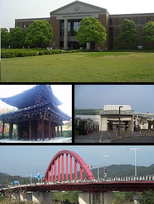

Kyōtanabe is a city in Kyoto Prefecture, Japan, home to about 74,000 people.
- Nearest airport
- ITM30 km · Osaka Itami International Airport
- Currency
- JPYJapanese yen
- Time zone
- Asia/TokyoUTC+9
- Plugs
- A, B · 100 V
- Emergency
- 110
- Language
- Japanese
Where to stay
More places to stay around Kyōtanabe
Overture Maps and OpenStreetMap list 7 further hotels and other places to stay in the Kyōtanabe area; none of them has a star rating and none has a room count.
By type: 5 hotels, guest houses, hostels and similar, no holiday rentals and 2 listed only as lodging.
The area is everything within 25 km that is nearer to Kyōtanabe than to any other destination in this guide. Places this guide already names are not counted again; a place listed by two sources under different names can be counted twice.
Sources: Overture Maps Foundation, places theme, release 2026-09-23.1 (CDLA Permissive 2.0); © OpenStreetMap contributors (ODbL 1.0), data of 21 September 2026.
Things to see
Things to see near Kyōtanabe
Places of interest within 6 km of the centre of Kyōtanabe, ranked first by how widely they are covered in Wikipedia (9 of them have articles), then the others, those linked to Wikidata first, by type of place and distance. Distances are in a straight line.
- 久世廃寺跡 archaeological site · 5.2 km
- 正道官衙遺跡 archaeological site · 5.3 km
- 平川廃寺跡 archaeological site · 5.4 km
- 芝ヶ原古墳 archaeological site · 5.6 km
- 久津川車塚古墳 archaeological site · 5.7 km
- 丸塚古墳 archaeological site · 5.8 km
- 芭蕉塚古墳 archaeological site · 6.0 km
- Mt. Kannabi peak, 221 m · 2.2 km
- サンドイッチ山 peak, 313 m · 5.3 km
- 同志社大学歴史資料館 museum · 1.4 km
- 竹取翁博物館 museum · 2.6 km
- 城陽市歴史民俗資料館 museum · 3.9 km
- Mantoroyama Scenic View Park viewpoint · 5.1 km
- 田辺公園 park · 0.1 km
- 長尾陣屋跡 viewpoint · 5.7 km
- トンボ池 viewpoint · 5.8 km
- 西方池 viewpoint · 5.8 km
- 新池 viewpoint · 5.8 km
- 北峰 peak, 240 m · 5.0 km
- 鏡谷山 peak, 176 m · 5.1 km
OpenStreetMap maps 126 restaurants, 31 cafes and 27 bars and pubs within 6 km of the centre.
Source: © OpenStreetMap contributors (ODbL 1.0), map data of 21 September 2026; links to Wikidata.
Nature
Nature near Kyōtanabe
Protected areas within 50 km
- Biwako Quasi-national Park 国定公園 · 8.1 km
- 明治の森箕面国定公園 24.9 km
Source: © OpenStreetMap contributors (ODbL 1.0), map data of 21 September 2026; links to Wikidata.
When to go
The best time to visit Kyōtanabe
Kyōtanabe has no month that is both mild and dry by the measure used here. August is the warmest month, with average highs of 33 °C; July is the wettest, with about 217 mm of rain.
Comfortable means average daytime high between 18 °C and 29 °C and under 80 mm of rain in the month. Averages for 1991-2020 over the surrounding area, a grid square about 50 km across, so a coast or a nearby mountain can make the town itself warmer or cooler. Data: CRU TS v4.10, Climatic Research Unit, University of East Anglia (Open Database License).
Public holidays in Japan, 2026
Shops and offices may close on these dates.
Getting there
Getting to Kyōtanabe: airports and arrival
The nearest airport with scheduled flights is Osaka Itami International Airport (ITM), about 30 km from the city centre in a straight line; Kobe Airport (UKB, 54 km) and Kansai International Airport (KIX, 64 km) are also within reach.
Getting around
Getting there and around Kyōtanabe by rail and ferry
Rail from the airports
Rail, metro and tram lines that call at a station at the airport, as mapped in OpenStreetMap.
- ITM · Osaka Itami International AirportMonorail: OM
- UKB · Kobe AirportLight rail (神戸新交通): P
- KIX · Kansai International AirportRail (南海電鉄): NK, S, 空港急行Rail (アーバンネットワーク): ORail: 特急はるか
Source: © OpenStreetMap contributors (ODbL 1.0), map data of 21 September 2026.
Questions
Kyōtanabe: questions travellers ask
When is the best time to visit Kyōtanabe?
Kyōtanabe has no month that is both mild and dry by the measure used here. August is the warmest month, with average highs of 33 °C; July is the wettest, with about 217 mm of rain.
Which airport is closest to Kyōtanabe?
The nearest airport with scheduled flights is Osaka Itami International Airport (ITM), about 30 km from the city centre in a straight line; Kobe Airport (UKB, 54 km) and Kansai International Airport (KIX, 64 km) are also within reach.
What currency is used in Kyōtanabe?
The Japanese yen (JPY), per Unicode CLDR.
Nearby
Destinations near Kyōtanabe
Sources: city facts from Wikidata and Wikipedia; airports from OurAirports; climate from CRU TS v4.10 (University of East Anglia Climatic Research Unit), 1991-2020 monthly means, 0.5° grid; public holidays from python-holidays (MIT); currency and official languages from Unicode CLDR (Unicode License v3); time zone from the coordinates (timezone-boundary-builder, ODbL) with offsets from the IANA Time Zone Database; places to stay and guest scores from each operator's own public pages; amenities from the operators' own listing data. How this guide is made.