Region: Saitama Prefecture · Japan
Where to stay in Saitama
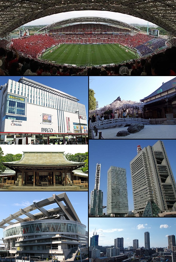

Saitama is a city in Saitama Prefecture, Japan, home to about 1,326,000 people. This guide covers 4 hotels in Saitama.
- Places to stay in this guide
- 4
- Nearest airport
- HND37 km · Tokyo Haneda International Airport
- Currency
- JPYJapanese yen
- Time zone
- Asia/TokyoUTC+9
- Plugs
- A, B · 100 V
- Emergency
- 110
- Language
- Japanese
About
About Saitama
Saitama is the capital and largest city of Saitama Prefecture, Japan. Its area incorporates the former cities of Urawa, Ōmiya, Yono and Iwatsuki.
If Tokyo is New York, then Saitama is New Jersey, a half industrial, half suburban commuter town agglomerated by bureaucratic fiat, and Tokyo snobs joke about Dasai-tama ("Uncool-(Sai)Tama"). But as the bonsai capital of the world and home to what is arguably Japan's best railway museum, Saitama has more to impress visitors than it's given credit for. It is also home to some of the most fervent soccer fans in Japan.
Wikipedia and Wikivoyage contributors, CC BY-SA 4.0; excerpted.
Things to do
What to see and do in Saitama
See
- Saitama Museum of Modern Art
- Hikawa Shrine
- Saitama Prefectural Museum of History and Folklore
- Railway Museum
- Sōji-in
- Tōgyoku Doll Museum
- Urawa Art Museum
- Jion-ji
- Omiya Bonsai Art Museum
- Fuyō-en
- Kyūka-en
- Seikō-en
Do
- Ōmiya kōen
- Omiya Park Zoo
- Saitama Super Arena
- Saitama Arts Theater
Wikivoyage contributors, CC BY-SA 4.0; excerpted.
Where to stay
Places to stay in Saitama
4 places to stay from the chains this guide covers, each linked to its own website.
Where to stay
More hotels in Saitama
5 hotels within 25 km of the centre, as recorded in Wikidata. Each name links to its encyclopedia article where there is one.
| Hotel | Opened | From centre |
|---|---|---|
| Hotel Metropolitan Saitama-Shintoshin Nippon Hotel | 3.8 km | |
| Palace Hotel Omiya | 1988 | 5.4 km |
| Royal Pines Hotel Urawa | 1999 | 0.6 km |
| 浦和ワシントンホテル | 1.0 km | |
| 浦和東武ホテル | 0.5 km |
Where to stay
Hotels near venues in Saitama
Stadiums, venues, stations and sights in Saitama, each with the places to stay near it by straight-line distance.
Where to stay
More places to stay around Saitama
Overture Maps and OpenStreetMap list 76 further hotels and other places to stay in the Saitama area; none of them has a star rating and none has a room count.
By type: 66 hotels, guest houses, hostels and similar, 1 holiday rental or apartment and 9 listed only as lodging.
The area is everything within 25 km that is nearer to Saitama than to any other destination in this guide. Places this guide already names are not counted again; a place listed by two sources under different names can be counted twice.
Sources: Overture Maps Foundation, places theme, release 2026-09-23.1 (CDLA Permissive 2.0); © OpenStreetMap contributors (ODbL 1.0), data of 21 September 2026.
Things to see
Things to see near Saitama
The best-known sights within 10 km of the centre of Saitama, ranked by how widely they are covered (mainly the number of Wikipedia language editions with an article on them). Distances are in a straight line.
- The Railway Museum museum · 7.1 km
- The Museum of Modern Art, Saitama museum · 0.9 km
- Ōmiya Park park · 6.5 km
- Saitama Prefectural Museum of History and Folklore museum · 6.8 km
- 秋ヶ瀬公園 park · 4.0 km
- Saitama City Museum museum · 5.7 km
- さいたま市立浦和博物館 museum · 4.3 km
- Saiko Douman Green Park park · 4.4 km
- Minuma Nature Park park · 6.7 km
- Ukima Park park · 8.6 km
- JGSDF Public Information Center museum · 9.5 km
- Urawa Art Museum museum · 0.6 km
- Konuma Museum museum · 1.9 km
- Saitama City Youth Space Science Museum museum · 2.1 km
- Toda City Museum of Local History museum · 5.0 km
- Asaka City Museum museum · 6.9 km
- Saitama City Manga Museum museum · 7.3 km
- Bonsai Art Museum museum · 7.6 km
- Kawaguchi Science Museum museum · 7.7 km
- Itabashi Historical Museum museum · 8.4 km
OpenStreetMap maps 1,215 restaurants, 253 cafes and 392 bars and pubs within 10 km of the centre.
Source: © OpenStreetMap contributors (ODbL 1.0), map data of 21 September 2026; links to Wikidata.
Nature
Nature near Saitama
Protected areas within 50 km
- 葛西沖三枚洲 鳥獣保護区 · 30.7 km
- 行徳鳥獣保護区 鳥獣保護区 · 32.4 km
Source: © OpenStreetMap contributors (ODbL 1.0), map data of 21 September 2026.
When to go
The best time to visit Saitama
Saitama has no month that is both mild and dry by the measure used here. August is the warmest month, with average highs of 32 °C; September is the wettest, with about 200 mm of rain.
Comfortable means average daytime high between 18 °C and 29 °C and under 80 mm of rain in the month. Averages for 1991-2020 over the surrounding area, a grid square about 50 km across, so a coast or a nearby mountain can make the town itself warmer or cooler. Data: CRU TS v4.10, Climatic Research Unit, University of East Anglia (Open Database License).
Public holidays in Japan, 2026
Shops and offices may close on these dates.
Getting there
Getting to Saitama: airports and arrival
The nearest airport with scheduled flights is Tokyo Haneda International Airport (HND), about 37 km from the city centre in a straight line; Narita International Airport (NRT, 68 km) and Ibaraki Airport (IBR, 78 km) are also within reach.
Getting in
The closest major international airport is Narita (NRT). A tiny number of JR Narita Express trains serve at Omiya Station-as of this writing, the 17:16 and 18:48 NEX departures from NRT T1 terminate at Omiya, and Omiya has two originating NEX services at 6:21 and 9:09. When it is available the NEX is fairly fast, taking around 110 minutes. At other hours, you can make it to Ōmiya station by taking the Narita Express to Tokyo and changing to the Tohoku/Joetsu Shinkansen; either route is covered by the Japan Rail Pass or JR East Pass.
Getting around
Most of the attractions are within walking distance of one of the city's train stations, but there are Community Buses with routes throughout the city.
Wikivoyage contributors, CC BY-SA 4.0; excerpted.
HND · Tokyo Haneda International Airport
NRT · Narita International Airport
IBR · Ibaraki Airport
Getting around
Getting there and around Saitama by rail and ferry
Rail from the airports
Rail, metro and tram lines that call at a station at the airport, as mapped in OpenStreetMap.
- HND · Tokyo Haneda International AirportRail (京急逗子線, 京急本線, 京急空港線): KKMetro (都営地下鉄): AlMetro (京成, 都営地下鉄): KS-AEMonorail (東京モノレール): MO
- NRT · Narita International AirportRail (京成電鉄): KS, 京成本線快特, 京成本線快速, 京成本線特急, 京成本線通特Rail: JO, JR成田線, SRRail (京成, 都営地下鉄): KS-AERail (JR成田エクスプレス): N'EXMetro (京成, 都営地下鉄): KS-AE
Metro, light rail and tram
- 埼玉高速鉄道線 (Metro): 1 line, 1 station in SaitamaLines: SR
- ニューシャトル (Light rail): 1 line, 6 stations in SaitamaLines: NS
Source: © OpenStreetMap contributors (ODbL 1.0), map data of 21 September 2026.
Local knowledge
Eating, drinking and staying safe in Saitama
Eat
Jūmangoku Manjū (十万石まんじゅう) is a famous brand of cake from Gyōda, Saitama. Manjyū is a Japanese-style bun stuffed with red bean paste. Some department stores and souvenir stores such as Sogo department in Omiya station always sell it. One manjyū is ¥105.
Wikivoyage contributors, CC BY-SA 4.0; excerpted.
Questions
Saitama: questions travellers ask
When is the best time to visit Saitama?
Saitama has no month that is both mild and dry by the measure used here. August is the warmest month, with average highs of 32 °C; September is the wettest, with about 200 mm of rain.
Which airport is closest to Saitama?
The nearest airport with scheduled flights is Tokyo Haneda International Airport (HND), about 37 km from the city centre in a straight line; Narita International Airport (NRT, 68 km) and Ibaraki Airport (IBR, 78 km) are also within reach.
What currency is used in Saitama?
The Japanese yen (JPY), per Unicode CLDR.
Nearby
Destinations near Saitama
Sources: city facts from Wikidata and Wikipedia; airports from OurAirports; climate from CRU TS v4.10 (University of East Anglia Climatic Research Unit), 1991-2020 monthly means, 0.5° grid; public holidays from python-holidays (MIT); currency and official languages from Unicode CLDR (Unicode License v3); time zone from the coordinates (timezone-boundary-builder, ODbL) with offsets from the IANA Time Zone Database; places to stay and guest scores from each operator's own public pages; amenities from the operators' own listing data. How this guide is made.